FEM Engineering AS
Leiv Eiriksson Senter
P.O.Box 1239 Pirsenteret
N-7462 Trondheim
Norway
TLF: +47 73546420
FAX: +47 73546425
info@femengineering.no |
|
GeoTOOL®
Main functionality of GeoTOOL® software
Importing of reservoir simulator / geologic grids
GeoTOOL® imports reservoir simulator (e.g. Eclipse, *.fix) and geologic (e.g. IRAP RMS, *.gri) file formats, and mainly converts / prepares them into Finite Element Grids.
Frame incorporation
Around the field a boundary frame can be added. This frame is incorporated to make the boundary of the field in a rectangular shape.
Also the frame can be rotated so that it is aligned along the regional stresses in the area.
The latest improvement in the software is implementation of the frame at the top and bottom of the field so that the entire field is
enclosed in a box. Frame incorporation will also act as over-, under- and sideburden. |
 |
Layer combination
 |
Layers can be merged together optionally to reduce the number of layers and thereby the number of elements. This option is very
useful if several layers have the same, or almost the same geo-mechanical properties. Reducing the number of elements means shorter
analysis time, and more different cases with different geo-mechanical properties or boundary conditions can be run in the same amount
of time. This combination of layers can also be applied for overburden and underburden where details are not required. |
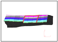
Area selection
From the original grid areas or sections can be selected optionally, and the rest of the grid deleted. This is useful if only selected areas,
for instance areas around faults, are of interest.
Also areas can be refined optionally so that the number of elements are increased. This can be performed for a section of the field, or for
the entire field. This fine gridding is useful if areas are of particular interest, and more accurate results are desired in these areas.
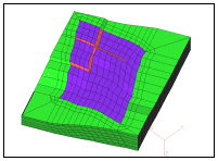
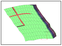
Faults modeling
GeoTOOL® can open the grids in the fault zones. This is one of the main purposes of
the software, but this is only possible for reservoir / geologic file formats in which the faults are defined, and therefore can be
opened. In the gap generated between the cell-faces elements are built. These elements are placed in their own unique group. This
makes it possible to add specific geo-mechanical properties to the faults.
It is also possible to smooth the faults so that there is connectivity in the grid. This means that the field can be analysed using any
FEM Software, but with no extra elements, and thereby with no unique geo-mechanical properties in the fault. |
 |
Exporting
The software is mainly used to export geometry files to any Finite Element Analysis program. The exported files contain only the geometry,
and no properties or boundary conditions. Geo-mechanical properties and boundary conditions have to be added in the FEM Software.
It is also possible to export files to an improved Reservoir Simulation model. The purpose of this data exporting is to modify the geometry
with merging layers, open faults, select areas of interest, and then re-use the file in, for instance, Eclipse with the modifications.
|
|